During the winter season, due to extreme cold in the snow-capped mountainous areas of Kashmir, it was a common practice for both the Indian and Pakistan Armies to abandon some forward posts on their respective sides of the LOC and to reduce patrolling of areas that may be avenues of infiltration. When weather conditions became less severe, forward posts would be reoccupied and patrolling resumed.
During February 1999, the
Pakistan Army began to re-occupy the posts it had abandoned on its side of the LOC in the Kargil region, but also sent forces to occupy some posts on the Indian side of the LOC Troops from the elite
Special Services Group as well as four to seven
battalions of the
Northern Light Infantry (a paramilitary regiment not part of the regular Pakistani army at that time) covertly and overtly set up bases on the vantage points of the Indian-controlled region. According to some reports, these Pakistani forces were backed by Kashmiri
guerrillas and Afghan
mercenaries
Pakistani intrusions took place in the heights of the lower Mushkoh Valley, along the Marpo La ridgeline in
Dras, in Kaksar near Kargil, in the Batalik sector east of the
Indus River, on the heights above of the Chorbatla sector where the LOC turns North and in the Turtok sector south of the
Siachen area.
The
Government of India responded with
Operation Vijay, a mobilisation of 200,000 Indian troops. However, because of the nature of the terrain,
division and
corps operations could not be mounted; subsequent fighting was conducted mostly at the regimental or
battalion level. In effect, two
divisions of the Indian Army numbering 20,000, plus several thousand from the
Paramilitary forces of India and the air force were deployed in the conflict zone. The total number of Indian soldiers that were involved in the
military operation on the Kargil-Drass sector was thus close to 30,000. The number of infiltrators, including those providing logistical backup, has been put at approximately 5,000 at the height of the conflict This figure includes troops from
Pakistan-administered Kashmir who provided additional artillery support.
The
Indian Air Force launched
Operation Safed Sagar in support of the mobilisation of Indian land forces, but its effectiveness during the war was limited by the high altitude and weather conditions, which in turn limited bomb loads and the number of
airstrips that could be used.
The infiltrators, apart from being equipped with
small arms and
grenade launchers, were also armed with
mortars,
artillery and
anti-aircraft guns. Many posts were also heavily
mined, with India later stating to have recovered more than 8,000
anti-personnel mines according to an
ICBLreport.Pakistan's
reconnaissance was done through
unmanned aerial vehicles and
AN/TPQ-36 Firefinder radars supplied by the US.The initial Indian attacks were aimed at controlling the hills overlooking NH 1D, with high priority being given to the stretches of the highway near the town of Kargil. The majority of posts along the Line of Control were adjacent to the highway, and therefore the recapture of nearly every infiltrated post increased both the territorial gains and the security of the highway. The protection of this route and the recapture of the forward posts were thus ongoing objectives throughout the war.
The Indian Army's first priority was to recapture peaks that were in the immediate vicinity of NH 1D. This resulted in Indian troops first targeting the Tiger Hill and Tololing complex in Dras, which dominated the Srinagar-Leh route.
[80] This was soon followed by the Batalik-Turtok sub-sector which provided access to Siachen Glacier. Some of the peaks that were of vital strategic importance to the Pakistani defensive troops were Point 4590 and Point 5353. While 4590 was the nearest point that had a view of NH 1D, point 5353 was the highest feature in the Dras sector, allowing the Pakistani troops to observe NH 1DThe recapture of Point 4590 by Indian troops on 14 June was significant, notwithstanding the fact that it resulted in the Indian Army suffering the most casualties in a single battle during the conflict. Though most of the posts in the vicinity of the highway were cleared by mid-June, some parts of the highway near Drass witnessed sporadic shelling until the end of the with
the Kargil War.
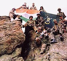
Once India regained control of the hills overlooking NH 1D, the Indian Army turned to driving the invading force back across the Line of Control. The
Battle of Tololing, among other assaults, slowly tilted the combat in India's favour. The Pakistani troops at Tololing were aided by Pakistani fighters from Kashmir. Some of the posts put up a stiff resistance, including Tiger Hill (Point 5140) that fell only later in the war. Indian troops found well-entrenched Pakistani soldiers at Tiger Hill, and both sides suffered heavy casualties. After a final assault on the peak in which ten Pakistani soldiers and five Indian soldiers were killed, Tiger Hill finally fell. A few of the assaults occurred atop hitherto unheard of peaks – most of them unnamed with only Point numbers to differentiate them – which witnessed fierce
hand to hand combat.
As the operation was fully underway, about 250 artillery guns were brought in to clear the infiltrators in the posts that were in the
line-of-sight. The
Bofors FH-77B field howitzer played a vital role, with Indian gunners making maximum use of the terrain. However, its success was limited elsewhere due to the lack of space and depth to deploy it.
It was in this type of terrain that
aerial attacks were used with limited effectiveness. French made
Mirage 2000H of the IAF were tasked to drop
laser-guided bombs to destroy well-entrenched positions of the Pakistani forces The IAF lost a
MiG-27 strike aircraft, which it attributed to an
engine failure, and a
MiG-21 fighter which was shot down by Pakistan; initially Pakistan said it shot down both jets after they crossed into its territory.One Indian
Mi-8 helicopter was also lost due to
Stinger SAMs. On 27 May 1999, Flt. Lt.
Nachiketa developed engine trouble in the Batalik sector and bailed out of his craft. Sqn Ldr
Ajay Ahuja went out of his way to locate his comrade but was shot down by a shoulder-fired Stinger missile. According to reports, he had bailed out of his stricken plane safely but was apparently killed by his captors as his body was returned riddled with bullet wounds.
In many vital points, neither artillery nor air power could dislodge the outposts manned by the Pakistani soldiers, who were out of visible range. The Indian Army mounted some direct frontal ground assaults which were slow and took a heavy toll given the steep ascent that had to be made on peaks as high as 18,000 feet (5,500 m). Since any daylight attack would be suicidal, all the advances had to be made under the cover of darkness, escalating the risk of freezing. Accounting for the
wind chill factor, the temperatures were often as low as −15 °C to −11 °C (12 °F to 5 °F) near the mountain tops. Based on
military tactics, much of the costly
frontal assaults by the Indians could have been avoided if the Indian Military had chosen to blockade the supply route of the opposing force, creating a
siege. Such a move would have involved the Indian troops crossing the LoC as well as initiating aerial attacks on Pakistani soil, a manoeuvre India was not willing to exercise fearing an expansion of the
theatre of war and reduced international support for its cause.
Two months into the conflict, Indian troops had slowly retaken most of the ridges that were encroached by the infiltrators; according to the official count, an estimated 75%–80% of the intruded area and nearly all the high ground were back under Indian control.


No comments:
Post a Comment